Thursday, January 10, 2013

What Are You Taklamakan About?

I must confess:  I haven't really been thinking all that much about Bactria lately.  Bactria, along with a great many other important things, has taken a backseat to the holidays, family, and work.  However, I have been thinking recently about Xuanzang, the famous Buddhist pilgrim of the 7th century, who recorded a wonderful snapshot of Buddhist Balkh on the eve of the Islamic Conquest of Bactria.  

In particular, I have been considering Xuanzang's journey into the Gobi and Taklamakan Deserts early in his travels.  The Gobi is a fairly well known desert by name and location, but perhaps not as well known is the Taklamakan Desert (Taklamakan, as explained by Dr. Anya King, is known to mean "you go in but you don't come out"), found in and around the Tarim Basin.

The Gobi Desert and the Taklamakan Desert.

A political map showing the Gobi and the Taklamakan Deserts.

Xuanzang's journey along the Silk Routes, the major highways for travel of that day, is an excellent account of the conditions travelers faced on the roads.  It was necessary for the monk to have a guide and a horse, of which he had both, though his guide was old and his horse was a skinny mare long past her prime.  The importance of vetting a guide becomes evident as well, since Xuanzang's guide tried to kill him in his sleep.  However, the guide left Xuanzang alone in the desert, and the monk made his way to a Chinese desert outpost, from which he entered the heart of the Gobi Desert.  The dangers of traveling the open desert soon become apparent to the monk.  He questioned things he was seeing, knowing mirages could lead travelers astray.  He encountered the bones of unlucky men and beasts in the desert.  He lost his water supply at one point, and, according to his hagiographer Hui-Li, was only saved through the divine protection of Guan Yin, a Bodhisattva that Xuanzang prayed to when he felt he was in danger.  Xuanzang also encountered bandits on numerous occasions in his travels, as the routes on the periphery of the empires, kingdoms, city-states, etc. were prone to raiding from bands of highwaymen.  Weather and political situations could also prove hazardous to travelers, a unstable governments lead to reduced security along the roads.

The northern Silk Route along the Taklamakan Desert is the route Xuanzang took after arriving at Hami.

There are two routes to choose from when desiring to go around the Tarim Basin and the Taklamakan Desert at its heart.  One is the northern route, along the Tian Shan mountains, were the oasis towns of Turfan, Aksu, and, further west, Kashgar.  On the southern route there were the towns of Khotan, Niya, Loulan, and Dunhuang.  These oasis towns were crucial to safe passage around the Taklamakan, as the desert is a dry, brutal salt basin prone to extreme cold and heat.  The mountains around Tarim Basin give seasonal snowfall and melts, creating rivers that drain into the desert where they disappear due to evaporation upon encountering the dry, arid conditions of the desert.  These seasonal rivers provided the much needed water for agriculture in the oasis towns, producing fruits and other goods to sustain the cities and engage in the trade.  Sericulture (cultivation of silk worms and the production of silk) also made its way to these areas from China along the Silk Routes.  These cities were known for the grand wealth and their strategic importance, and were often the subject of conquests by invading forces, from the successive invasions of the nomadic confederations, to the Chinese, to the Islamic Conquests.  

This map is terrible, but it was the best I could find to show the names, listed in white, of the oasis towns.
As I mentioned earlier, Xuanzang's religious devotions and prayer during his trials in the desert were not an uncommon practice among travelers of that time.  Traveling was a dangerous proposition, and any number of ill fates could befall a caravan.  This is the time of the omens, of consulting wise men, religious figures, and divination for advice on when to leave and what route would be safest to travel.  To show their gratitude, demonstrate piety, and earn a little merit, wealthy merchants and travelers would often commission Buddhist carvings, paintings, manuscripts, or entire Buddhist cave shrines to be constructed.  These sites were important places of pilgrimage and learning for Buddhist monks, who received patronage from local government officials in China as well as wealthy, private individuals.  Two famous Buddhist cave complexes are the ones at Dunhuang (including Mogao and other cave complexes) and the Bezeklik caves at Turfan and Loulan.  These shrines were elaborately decorated, some with portraits of their patrons along with various depictions of Buddhist legends, Bodhisattvas, and various incarnations of the Buddha.  These caves must have been welcome sights of civilization to travelers weary after their long journeys.

Though Xuanzang did not have much use for the caves.  When pressured to stay and visit the caves at Dunhuang by a Buddhist watchman, he insisted he go forward on his pilgrimage to India, even if it meant wandering the desert thirsty, with no guide, a skinny horse and a Bodhisattva.  Such was the devotion of the monk.

Bibliography

Hwui-Li.  The Life of Hiuen-Tsang. trans. Samuel Beal.  Kegan Paul, Trench, Trubner & Co: London. 1911.  Elibron Classics replica edition. 2005.

Wriggins, Sally Hovey. The Silk Road Journey with Xuanzang.  Wrestview Press: Boulder, CO.  2004.

Thursday, November 8, 2012

The Geography of Bactria

Understanding the Silk Routes and the Political Geography of Bactria is a key launching point into this area of study.  The town of Balkh/Bactra was situated at the focal point of two very important routes:  The east/west route to and from China and the north/south route into al-Sind and al-Hind (modern Pakistan and India). 


The Silk Routes around the 1st Century CE. 
This first map shows that there was no one all-encompassing "Silk Road" but, in fact, a network of land and sea routes spanning across Central Eurasia and linking the world, from Europe, to Africa, all the way to India and China.  The land routes traversed various perilous terrains, ranging from scorching desert to frigid and treacherous mountain ranges.  The following map demonstrates the physical geography of the Silk Routes.  Note the expansive size of the desert in the Tarim Basin in Xinjiang/China, the mountain ranges surrounding India, and the general high elevation of the Iranian Plateau, lending to dry conditions therein.


Balkh itself is situated on the Bactrian Plain near the Balkh River, which lent to irrigation and flourishing of agriculture in the area.  Goods produced here, as attested in the Hudud al-Alam (The Regions of the World) include "citrons and sour oranges (turunj-u-naranj), sugar-cane (nay-shakar), and water-lilies (nilufar "lotus")".  The close proximity to the Amu Darya (Oxus) River granted Balkh excellent pasture land for nomadic herders.  Because of its ideal location as a hub of trade routes, Balkh had an extensive market-based economy, trading in manufactured and imported goods.  

This map shows the location of Balkh, marked here as Bactres, near the Amu Darya and Balkh rivers on Bactrian Plain
The compounding effect of devastating invasions, gradual climate change, a shift in trade routes, and an outbreak of malaria lent to the steady decline of Balkh.  However, even in decline the city was respected as a center of learning, a characteristic it maintained since ancient times as a center of Buddhist and, later, Islamic education.  When the capital of Balkh Province was moved to Mazar-e-Sharif, Balkh became a cluster of ruins.  However, many sites indicating the old splendor of the region remain, such as the site of the Green Mosque, built by Timurid conquerors in the 15th century.  As late as 1924-25, four stupas of monumental size were visible, though in a ruinous condition in Balkh.  Interestingly, one of the largest and most elaborate stupas corresponds to the location of the famous Naw Bahar, the grand Buddhist temple attested to in multiple accounts of Balkh.

This map shows the location of modern Balkh Province in Afghanistan.

 
   This map shows Balkh province with the city of Balkh in the middle of the province.


Bibliography

Anonymous. Hudud al-Alam: The Regions of the World. Trans. V. Minorsky ed. C.E. Bosworth. Gibb Memorial Trust: Cambridge. 1982.

de Planhol, X. "BALḴ: i. Geography".  Encyclopedia Iranica Online. http://www.iranicaonline.org/articles/balk-town-and-province

Paul, Jürgen. "Balkh." Encyclopaedia of Islam, THREE . Edited by: Gudrun Krämer, ; Denis Matringe, ;John Nawas and ; Everett Rowson. Brill, 2010. Brill Online. Indiana University Bloomington. 31 December 2010. http://www.brillonline.nl/subscriber/entry?entry=ei3_SIM-23449

World Architecture Map. "The Green Mosque". http://www.worldarchitecturemap.org/buildings/green-mosque-balkh

Maps 1-4 from Wikimedia Commons.  Map 5 from the Ministry of Foreign Affairs of Denmark website.


Sunday, September 16, 2012

Research Topic - Everyday Bactria

In a previous post, you might remember that I was amused with the sales receipts present in the Bactrian Documents.  Such a seemingly insignificant piece of parchment has extremely interesting and wonderful information about the daily lives of Bactrians, namely what sorts of goods were purchased and consumed by everyday people.  These receipts bring the past home in a very personal, almost charming way, demonstrating that their habits of consumption and lifestyle were not so different than our own modern consumption patterns.  With an eye to patterns of trade and consumption, I will endeavor to paint a picture of everyday life from the source material in the Bactrian Documents.  Here's some preliminary questions that I will strive to address, keeping in mind this is an evolving project and, as such, more questions will undoubtedly arise while I am conducting my research:

- Goods traded within Bactria are well known and listed in primary sources, but who was using these sources?  Was it the common people or those in higher stations within society?

- Types of goods exchanged for a marriage.  What was highly valued?

- Time period to be surveyed shall be that of the time period covered by the Bactrian Documents, roughly the Kushan Era, Hephtahlites, Sasanians, and a tiny smidge of the Arab Conquest.

This is no small task, and I realize the road from construction of a research article to actual publication is a very, very long one, but I will document it here for those who might be interested to follow my progress.  Join me as I heap loads of work upon myself for no real reason other than to seek information and research an area of interest that is near and dear to my heart.

Wednesday, May 30, 2012

Achaemenid Architecture Gets a Cameo in Marvel's Avengers

By now, most people on this planet, and perhaps even inhabiting this region of the galaxy, have seen or are at least aware of The Avengers, the Joss Whedon directed juggernaut (see what I did there?) destroying Box Office records the world over.  However, there was one brief moment that I, and perhaps a few others who are far nerdier than most, noticed.  Spoilers ahead, in case there is one soul left who hasn't seen the movie:


The scene in Stuttgart, Germany, where Loki appears at some generic Gala event where wealthy people cloister to drink and be wealthy together, seems to be taking place around a distinctive piece of Achaemenid Architecture: A Bull Capital.  This style of capital is a prevalent and recognizable motif in Achaemenid Architecture seen in palace and government buildings such as, for example, at the palace complex of Persepolis.  Depicted below is an example of such a capital:

(image source: Wikipedia)

And here is the set piece used in The Avengers:

(image source: Marvel's The Avengers)

This just goes to show there really is something for everyone in The Avengers!

Tuesday, March 13, 2012

The Bactrian Documents vol I and II

The Bactrian Documents, translated by Nicholas Sims-Williams, are valuable, first hand documents written in the Bactrian language pertaining to everyday life in pre-Islamic Bactria.  The documents can vary from being as important as Buddhist texts or legal/marriage contracts to receipts for goods purchased and received from one person to another.  While the marriage contract is interesting to read, I honestly find the receipts to be very interesting and even slightly amusing to read.  It makes me chuckle to think of reading someone's old grocery shopping receipt from the Kushan era and finding that people back then shopped for things not so different than what we shop for today.  Such as in Document B:

"The year 137, the month Shabat,
There has been received by me, Aspal-bid, from you, Zuwanind, the store-keeper, what is written in the list:forty measures of flour and grain, twelve jars of wine, ten sieves, ten bags of straw, fourteen bundles of lucerne, one chicken.  So this (is) your proof (of receipt). " (1)

The contracts contained herein are also fascinating.  Document A is a marriage contract, wherein a woman named Ralik is married to brothers,  Bab and Piduk.  I'm not sure how common it was for one woman to be married to two men.  The reading here seems to be pretty clear on the matter, though:
"Now:There has been requested by me, Bag-farn, from you, Far-wesh, and from you, Nog-sanind, this woman whose name (is) Ralik (as) a fully privledged daughter-in-law, (as) a wife for these (my) sons, Bab and Piduk..." (2)
The document also goes on to say:
"And a declaration was made (by us), Bab and Piduk.  We have received Ralik - I, Bab, and (I), Piduk - (as) a wife (to be treated) like a wife in every home which we now have and also which we may acquire in the future, (as) a lady possessing authority, as (is) the established custom in the land." 
I immediately drew correlations in this practice here to the practice mentioned in the Bible of how Jewish men would marry the wives of their dead brothers, and any children had in that relationship would belong to the dead brother.  Mongol men would marry their stepmothers if their father died, or marry their brother's wives in order to keep the women in the family and afford them social security and protection.  This appears to be similar to that in some regard, though I wonder if both these men engaged in intercourse with her.  At least they would know someone was fathering the children, though probably not which brother was successfully producing offspring with her.

Other documents included in the volumes include contracts for sales of items and slaves.  Loan contracts were also present, describing their interest rate, penalties, and items and/or amounts of money loaned.  There are also Buddhist texts and private correspondence, as well as a few legal proclamations.  The documents bring to life the workings of an advanced, organized society.  These types of primary sources are my favorite because they demonstrate that people, living in the years approximately from 200-400 A.D, were not so different from us at all, and desired and valued similar things to modern people.  They needed clear legal rulings for property inheritence, grievances, and criminal justice.  They utilized marriage contracts to negotiate rights for newly married women and their roles in their new households.  They shopped in markets for goods to feed their families. They wrote expressive, elegant letters to one another and they wrote beautiful hymns to the Buddha.  The Bactrian Documents are a significant and integral source of information for Bactrian scholarship and crucial to understanding the rich history of this important area.


Thursday, March 8, 2012

A Quick Note on Issues in Translation

As I've been translating Ibn al-Faqih and his account of the Balkh and the Barmakids, my professor and I have always understood that Naw Bihar = New Vihara.  Vihara, of course, is the name for Buddhist temples.  In reading other translations of primary source material, however, I have noticed that other authors have translated or understood Naw Bihar to be a reference to Fire Temples aka Zoroastrian places of worship.  So far, I've been unable to understand why this happens, because as far as I can tell, there's a pretty clear difference between the translation of the name of Zoroastrian places of worship and Buddhist places of worship. Even more than that, Richard Bulliet, in his article "Naw Bahar and the Survival of Iranian Buddhism" suggests there may have been a particular strain of Iranian Buddhism, itself distinct and different from the Mahayana and Theravada schools of Buddhism.  There were many "Naw Biharas" located through Tocharistan into Iran (Iranian-speaking or Iranian-influenced places), with the name meaning "New Spring" in Persian.  Without further archaeological evidence, as Bulliet laments, there is no hard evidence for a distinctly Persian flavor of Buddhism.

On another related note to the issues of Zoroastrianism and Buddhism is the issue of the Barmakids.  Bulliet states rather plainly the notion has been dispelled in recent scholarship that the Barmakids were descended of Zoroastrian priestly origins, and rather have origins in the Buddhist priestly class, taking their name Barmak from the title of the leader of the monastery.  More than that, the Barmak probably had vast regional authority in Bactria and Tocharistan.   In my translation work of Ibn al-Faqih, I've come across a passage on a rather well-known incident, describing the indignation of the King of Kabul over the conversion of Barmak abu Barmak abu Khalid to Islam.  The king fired off a letter to the new Barmak, the son of the previous, though now-converted, Barmak, who went by the new name Abd Allah, describing his feelings over the matter, saying what amounted to "nothing good has ever come from Islam".  The leader of one Buddhist monastery in Balkh, even though highly important in its time, would not have attracted such attention of local rulers with a move like this unless his authority was more than just religious in nature.  Likely, he was a powerful temporal as well as spiritual authority, perhaps akin to a Pope or a Caliph? That is pure speculation on my part, though an educated guess, nevertheless.

Once again, I'll leave the matter of the Barmakids to another post.  For now, just remember that when looking at a translated text, what you're reading always passes through the lens of one or more translators, and their finished product may not always be a perfect mirror of the original text.


Tuesday, February 7, 2012

The Prof gets side-tracked: Alexander and Roxanna

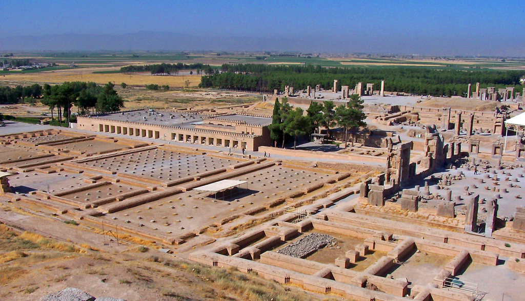
I haven't read this anywhere myself, but one day in my History of Iran class, a few students asked about the story of Alexander getting drunk and burning down Persepolis.  My professor then told us of how Roxanna, Alexander's Persian wife, got him wasted one night and he drunkenly decided it would be a good idea to burn the extensive palace complex of Persepolis to the ground.  Persepolis, as we should note, was the grandiose palace at which the Achaemenids received their yearly tribute from their Satraps and other visiting dignitaries for the Noruz (New Year) festival.


Visitors bringing tribute to the king


A broader view of Persepolis

My teacher went on to relate that after waking up from his hangover and realizing what he had done, Alexander wept bitterly for the destruction of Persepolis.  I have no idea if any of this is historically accurate or not, but it makes for an amusing story.